From the NHC’s Hurricane Harvey bulletin, just out…
000
WTNT34 KNHC 251452
TCPAT4BULLETIN
Hurricane Harvey Advisory Number 21
NWS National Hurricane Center Miami FL AL092017
1000 AM CDT Fri Aug 25 2017…OUTER RAINBAND FROM HARVEY SWIPING THE LOWER AND MIDDLE TEXAS
COASTS…
…CATASTROPHIC FLOODING EXPECTED ACROSS PORTIONS OF SOUTHERN AND
SOUTHEASTERN TEXAS…SUMMARY OF 1000 AM CDT…1500 UTC…INFORMATION
———————————————–
LOCATION…26.7N 96.0W
ABOUT 115 MI…185 KM SE OF CORPUS CHRISTI TEXAS
ABOUT 120 MI…195 KM SSE OF PORT OCONNOR TEXAS
MAXIMUM SUSTAINED WINDS…110 MPH…175 KM/H
PRESENT MOVEMENT…NW OR 315 DEGREES AT 10 MPH…17 KM/H
MINIMUM CENTRAL PRESSURE…947 MB…27.97 INCHESWATCHES AND WARNINGS
——————–
CHANGES WITH THIS ADVISORY:The Hurricane Watch south of Port Mansfield Texas to the Mouth of the Rio Grande has been discontinued.
SUMMARY OF WATCHES AND WARNINGS IN EFFECT:
A Storm Surge Warning is in effect for…
* Port Mansfield to High Island TexasA Storm Surge Watch is in effect for…
* South of Port Mansfield Texas to the Mouth of the Rio GrandeA Hurricane Warning is in effect for…
* Port Mansfield to Sargent TexasA Tropical Storm Warning is in effect for…
* North of Sargent to High Island Texas
* South of Port Mansfield Texas to the Mouth of the Rio GrandeA Tropical Storm Watch is in effect for…
* South of the Mouth of the Rio Grande to Boca de Catan MexicoA Storm Surge Warning means there is a danger of life-threatening inundation from rising water moving inland from the coastline in the
indicated locations. For a depiction of areas at risk, please see the National Weather Service Storm Surge Watch/Warning Graphic, available at hurricanes.gov. This is a life-threatening situation. Persons located within these areas should take all necessary actions to protect life and property from rising water and the potential for other dangerous conditions. Promptly follow evacuation and other instructions from local officials.A Hurricane Warning means that hurricane conditions are expected somewhere within the warning area, in this case within the next 12 to 24 hours. Preparations to protect life and property should be rushed to completion.
A Storm Surge Watch means there is a possibility of life- threatening inundation from rising water moving inland from the coastline in the indicated locations.
Interests in southwestern Louisiana should continue to monitor the progress of this system.
For storm information specific to your area in the United States, including possible inland watches and warnings, please monitor products issued by your local National Weather Service forecast office. For storm information specific to your area outside the United States, please monitor products issued by your national meteorological service.
DISCUSSION AND 48-HOUR OUTLOOK
——————————
At 1000 AM CDT (1500 UTC), the eye of Hurricane Harvey was located by an Air Force Reserve Hurricane Hunter aircraft and NOAA Doppler radar near latitude 26.7 North, longitude 96.0 West. Harvey is moving toward the northwest near 10 mph (17 km/h), but its forward speed is expected to decrease significantly during the next couple of days. On the forecast track, Harvey will make landfall on the middle Texas coast tonight or early Saturday. Harvey is then likely to meander near or just inland of the middle Texas coast through the weekend.Maximum sustained winds are near 110 mph (175 km/h) with higher gusts. Some strengthening is possible, and Harvey is forecast to become a major hurricane before it reaches the middle Texas coast.
Hurricane-force winds extend outward up to 35 miles (55 km) from the center, and tropical-storm-force winds extend outward up to 140 miles (220 km). A buoy located about 40 miles east of South Padre Island recently reported sustained winds of 42 mph (68 km/h) and a gust to 54 mph (86 km/h).
The minimum central pressure based on data from the Air Force plane is 947 mb (27.97 inches).
HAZARDS AFFECTING LAND
———————-
RAINFALL: Harvey is expected to produce total rain accumulations of 15 to 25 inches and isolated maximum amounts of 35 inches over the middle and upper Texas coast through next Wednesday. During the same time period Harvey is expected to produce total rain accumulations of 5 to 15 inches in far south Texas and the Texas Hill Country over through southwest and central Louisiana. Rainfall of this magnitude will cause catastrophic and life-threatening flooding.STORM SURGE: The combination of a dangerous storm surge and the tide will cause normally dry areas near the coast to be flooded by rising waters moving inland from the shoreline. The water is expected to reach the following heights above ground if the peak surge occurs at the time of high tide…
N Entrance Padre Island Natl Seashore to Sargent…6 to 12 ft
Sargent to Jamaica Beach…5 to 8 ft
Port Mansfield to N Entrance Padre Island Natl Seashore…5 to 7 ft
Jamaica Beach to High Island…2 to 4 ft
Mouth of the Rio Grande to Port Mansfield…2 to 4 ft
High Island to Morgan City…1 to 3 ftThe deepest water will occur along the immediate coast near and to the northeast of the landfall location, where the surge will be accompanied by large and destructive waves. Surge-related flooding depends on the relative timing of the surge and the tidal cycle, and can vary greatly over short distances. For information specific to your area, please see products issued by your local National Weather Service forecast office.
WIND: All last-minute preparations should be rushed to completion since tropical storm conditions are likely just beginning in portions of the hurricane and tropical storm warning areas. Hurricane conditions are likely to begin within the hurricane warning area later today or tonight. Tropical storm conditions are likely to persist along portions of the coast through at least Sunday.
SURF: Swells generated by Harvey are affecting the Texas, Louisiana, and northeast Mexico coasts. These swells are likely to cause life-threatening surf and rip current conditions. Please consult products from your local weather office.
TORNADOES: A few tornadoes are possible later today through Saturday near the middle and upper Texas coast.
NEXT ADVISORY
————-
Next intermediate advisory at 100 PM CDT.
Next complete advisory at 400 PM CDT.$$
Forecaster Berg
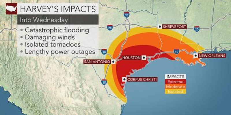
The forecast track of the storm has it slowing to a crawl once coming onto land somewhere near Port Aransas, Texas, just up the coast from Corpus Christi, and then bouncing back to the east – perhaps even going back out onto water. Click here for a detailed description of the NHC’s Hurricane Harvey forecast.
Here was the forecast map…

Having this thing bounce back into the Gulf and then make a beeline for Houston on Tuesday is really not the plan we all wanted to see. But it’s what we have.
Advertisement
We’ll keep you up to date on Hurricane Harvey as developments occur.
Advertisement
Advertisement