As the power here at Hayride Central tends to go out at the drop of a hat when a storm comes, we can’t guarantee chronic updates once it gets goofy around here. So by this afternoon if we seem to go a little dark, forgive us.
The forecast for Baton Rouge isn’t that we’re going to get anything monstrous. Probably no more than tropical storm strength winds. But the storm is supposed to slow down to such an extent that we’re going to get those winds for TWELVE HOURS, maybe more. The storm has slowed all the way down to seven miles per hour as it approaches us; that’s what we were afraid of.
Trees+Power Lines+Wind+12 Hours=power outages like you wouldn’t believe. So it’s going to suck.
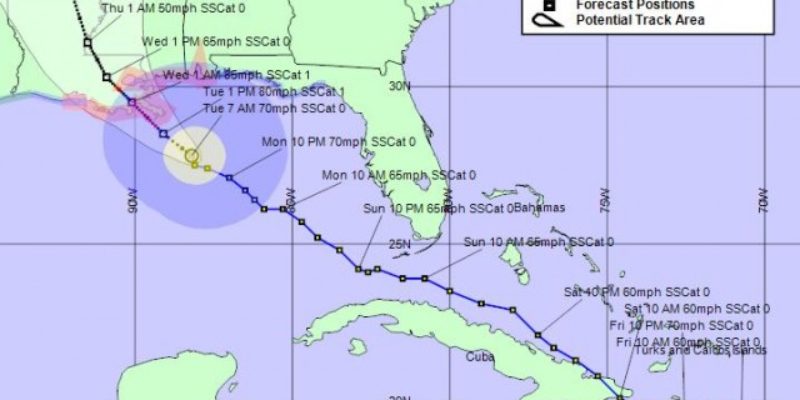
A new forecast map…

The track is the same; it’s still supposed to come in on the west side of the Mississippi and then roll in along the river from there.
But as of the 7 AM update, it still wasn’t a hurricane. Despite the pressure dropping to 976 millibars, which is a healthy Cat 2 storm, Isaac just hasn’t strengthened like it was supposed to. Can’t complain about that.
More from the NHC update…
DISCUSSION AND 48-HOUR OUTLOOK
——————————
AT 700 AM CDT…1200 UTC…THE CENTER OF TROPICAL STORM ISAAC WAS
LOCATED NEAR LATITUDE 27.8 NORTH…LONGITUDE 88.2 WEST. ISAAC IS
MOVING TOWARD THE NORTHWEST NEAR 7 MPH…11 KM/H…AND THIS GENERAL
MOTION IS EXPECTED TO CONTINUE FOR THE NEXT DAY OR TWO WITH SOME
FLUCTUATIONS IN FORWARD SPEED. ON THE FORECAST TRACK…THE CENTER
WILL BE NEAR OR OVER THE LOUISANA COAST TONIGHT OR EARLY WEDNESDAY.MAXIMUM SUSTAINED WINDS ARE NEAR 70 MPH…110 KM/H…WITH HIGHER
GUSTS. STRENGTHENING IS FORECAST…AND ISAAC IS LIKELY TO BECOME A
HURRICANE LATER TODAY. ADDITIONAL STRENGTHENING IS FORECAST UNTIL
THE CENTER MOVES INLAND.TROPICAL-STORM-FORCE WINDS EXTEND OUTWARD UP TO 205 MILES…335 KM
FROM THE CENTER.THE MINIMUM CENTRAL PRESSURE RECENTLY REPORTED BY AIR FORCE RESERVE
AND NOAA HURRICANE HUNTER AIRCRAFT WAS 976 MB…28.82 INCHES.HAZARDS AFFECTING LAND
———————-
STORM SURGE…THE COMBINATION OF A STORM SURGE AND THE TIDE WILL
CAUSE NORMALLY DRY AREAS NEAR THE COAST TO BE FLOODED BY RISING
WATERS. THE WATER COULD REACH THE FOLLOWING DEPTHS ABOVE GROUND IF
THE PEAK SURGE OCCURS AT THE TIME OF HIGH TIDE…* SOUTHEAST LOUISIANA AND MISSISSIPPI…6 TO 12 FT
* ALABAMA…4 TO 8 FT
* SOUTH-CENTRAL LOUISIANA…3 TO 6 FT
* FLORIDA PANHANDLE…3 TO 6 FT
* FLORIDA WEST COAST INCLUDING APALACHEE BAY…1 TO 3 FTTHE DEEPEST WATER WILL OCCUR ALONG THE IMMEDIATE COAST IN AREAS OF
ONSHORE WINDS. SURGE-RELATED FLOODING DEPENDS ON THE RELATIVE
TIMING OF THE SURGE AND THE TIDAL CYCLE…AND CAN VARY GREATLY OVER
SHORT DISTANCES. FOR INFORMATION SPECIFIC TO YOUR AREA…PLEASE
SEE PRODUCTS ISSUED BY YOUR LOCAL WEATHER SERVICE OFFICE. NEAR THE
COAST…THE SURGE WILL BE ACCOMPANIED BY LARGE AND DANGEROUS WAVES.WIND…TROPICAL STORM CONDITIONS ARE EXPECTED TO REACH THE NORTHERN
GULF COAST IN THE HURRICANE WARNING AREA THIS MORNING…WITH
HURRICANE CONDITIONS EXPECTED BY THIS AFTERNOON.TROPICAL STORM CONDITIONS ARE EXPECTED TO SPREAD NORTHWARD
INTO THE FLORIDA BIG BEND AREA AND THE FLORIDA PANHANDLE IN THE
TROPICAL STORM WARNING AREA THIS MORNING.TROPICAL STORM CONDITIONS ARE EXPECTED WITHIN THE TROPICAL STORM
WARNING AREA IN LOUISIANA BY TONIGHT. TROPICAL STORM CONDITIONS
ARE POSSIBLE ON THE COAST OF SOUTHWESTERN LOUISIANA AND THE UPPER
TEXAS COAST BY TONIGHT OR EARLY WEDNESDAY.RAINFALL…ISAAC IS EXPECTED TO PRODUCE TOTAL RAINFALL AMOUNTS OF
7 TO 14 INCHES…WITH POSSIBLE ISOLATED MAXIMUM AMOUNTS OF 20
INCHES…IN SOUTHEASTERN LOUISIANA…SOUTHERN MISSISSIPPI…
SOUTHERN ALABAMA…AND THE EXTREME WESTERN FLORIDA PANHANDLE.
THESE RAINS COULD RESULT IN SIGNIFICANT LOWLAND FLOODING.TORNADOES…TORNADOES MAY OCCUR ALONG THE NORTHERN GULF COAST TODAY.
SURF…DANGEROUS SURF AND RIP CURRENT CONDITIONS WILL CONTINUE TO
AFFECT THE FLORIDA COASTLINE AND PORTIONS OF THE NORTHERN GULF COAST
FOR THE NEXT DAY OR SO.
They’ve closed the flood gates in Morgan City, although from the looks of it that burg will largely be spared since it’s catching the west side of the storm. Storm surge is a decent possibility, though.
And it’s already flooding in Grand Isle.
A ton of schools and other facilities are closed today and tomorrow.
All of the New Orleans metro area is under a flash flood watch.
Don’t try to cross Bayou Lafourche today, unless it’s on a zipline or in a pirogue.
And they won’t let you ride a motorbike across the Causeway right now. Don’t even think about driving a glass truck across that bridge, either. Seriously.
Advertisement
Advertisement