(Citizens for a New Louisiana) — St Bernard of Clairvaux is credited with authoring the phrase: “The road to hell is paved with good intentions.” Good intentions are not a substitute for lawful structure. In government, poorly designed authority does not merely fail—it sets precedent. And precedent, once established, is difficult to undo.
When we received a letter last week from a well-respected legal mind in Opelousas regarding the Opelousas Downtown Development District, the message was clear: we should take a closer look at the statute (which he kindly included). The implication was that our initial assessment relied too heavily on surface conclusions—and that a deeper examination would be enlightening.
We took that suggestion seriously. What followed was less like a clarification and more like a discovery. Structural defects emerged that only become visible when the law is examined line by line. The closer we looked, the less stable the foundation became. What began as an invitation to look deeper appears to have revealed a fatal flaw—one that calls into question the constitutionality of a tax that’s been levied for the last eight years.
An Indeterminable Boundary
The Opelousas Downtown Development District (ODDD) began with a simplistic boundary description. The legislation that created the district in 2005 provided:
The district shall be composed of the existing Historic District, bordered to the north by the EW Railroad, to the south by Bertheaud Street, to the west by the NS Railroad, and to the east by Lombard Street.
For years, the ODDD operated under an assumption shared by officials, planners, and much of the public. The Legislature created the district, its boundaries — and therefore its authority — must be clear. Taxes were collected. Plans were adopted. Dollars were spent.
Then, in 2017, Senator Gerald Boudreaux (D 1/10) and Representative Dustin Miller (D 3/10) sought to make substantial changes to the district and specifically its boundaries. Act 326 drastically changed the district boundaries. That 2017 amendment is where the district’s legal foundation begins to fail.
…the district shall include the following perimeter: beginning at I-49, Exit 19 Ramp where ramp crosses over E. Grolee Street; then proceeding south along I-49 S. Service Road to the intersection of E. Laurent Street; then proceeding west to the intersection of Vincent Street; then proceeding north to the intersection of E. South Street; then proceeding west to the intersection of S. King Street; then proceeding south to the intersection of E. Madison Street; then proceeding west to the intersection of S. Walnut Street; then proceeding south to the intersection of Leonard Street; then proceeding east to the intersection of Edith Street; then proceeding south to the intersection of Creswell Lane; then proceeding west to the intersection of Joyce Drive; then proceeding south to the intersection of Abdalla Blvd.; then proceeding south to Hemlock Drive; then proceeding south to the intersection of Heather Drive; then proceeding west to the intersection of Heather Drive and the eastern boundary line of the Parcel No. 10579100; then continuing south approximately 210 feet along the eastern boundary to the southeast property corner of Parcel No. 10579100 located in the southeast quadrant of the S. Union Street and Heather Drive intersection; then proceeding west approximately 400 feet along the southern boundary of Parcel No. 10579100 to the intersection with South Union Street; then proceeding south along South Union Street for approximately 140 feet to the intersection with the southern boundary line of Parcel No. 101858300 located in the southwest quadrant of the S. Union Street and Heather Drive intersection; then proceeding west approximately 525 feet along the southern boundary to the southwest property corner of Parcel No. 101858300; then proceeding north for approximately 800 feet along Parcel No. 101858300 and 0105789500 western boundary line to northwest property corner located in the northwest quadrant of the S. Union Street and Heather Drive intersection; then proceeding east along the northern boundary of Parcel No. 0105789500 for approximately 850 feet to the western right-of-way line of S. Union Street; then proceeding in a northern direction along the western right-of-way line of S. Union Street for approximately 3,300 feet to the southern boundary of Parcel No. 9110421578; then proceeding west along the southern boundary of Parcel No. 9110421578 to the intersection with Bayou Tesson; then proceeding north along Bayou Tesson to the intersection with the northern boundary of Parcel No. 9110421578; then proceeding east along the northern boundary of Parcel No. 9110421578 to the intersection with the western right-of-way line of S. Union Street; then proceeding in a northern direction along the western right-of-way line of S. Union Street to the intersection with E. Bertheaud Ave.; then proceeding west to the intersection of S. Court Street; then proceeding north to the intersection of W. South Street; then proceeding west to the intersection of S. Bullard Street; then proceeding north to the intersection of W. Bellevue Street; then proceeding east to the intersection of S. Court Street; then proceeding north to Redmond Street; then continuing north to the intersection of E. Martin Luther King Jr. Drive; then proceeding east to the intersection of Main Street; then continuing east to the projected intersection of E. Martin Luther King Jr. Drive and Cherokee Drive; then proceeding north along Cherokee Drive until intersection with Natchez Blvd.; then proceeding west along Natchez Blvd. to the intersection with a line located 350 feet east and parallel to Main Street; then proceeding south along said line running parallel to Main Street to the intersection of E. Prudhomme Lane; then proceeding west to the eastern right-of-way line of Main Street; then proceeding south along the eastern right-of-way line of Main Street to the intersection of E. Church Street; then proceeding east to the intersection of N. Union Street; then proceeding south to the intersection of Perry Lane; then proceeding east to the intersection of N. Walnut Street; then proceeding south to the intersection of E. Bellevue Street; then proceeding east to the intersection of N. Cane Street; then proceeding north to the intersection of E. Grolee Street; then proceeding east on E. Grolee Street until street crosses under I-49, Exit 19 Ramp.
This is not a surveyed boundary. It is a narrative approximation masquerading as law, and taxation cannot rest on approximation. A taxing district is not a theory. It is a vehicle for compulsory payment. And presuming legality without verification is how governments end up pedaling confidently in the wrong direction.
How the Boundary Was Re-Written — and Why That Alone Should Have Raised Alarms
That 2017 amendment is where the district’s legal foundation begins to fail. Rather than adopting a surveyed legal description or a recorded plat — the traditional tools used to fix governmental boundaries — lawmakers relied on a hybrid narrative description. That description uses streets and intersections, railroads and bayous, parcel numbers, and repeated distance calls described only as “approximately.”
This matters because a special district is not a planning exercise. It is a taxing authority. Taxing authority requires certainty. Citizens must be able to know, without guesswork, whether they are inside or outside the reach of government taxing power. That certainty is missing here.
No one stopped to ask the most basic question the government must always answer first: Where, exactly, does this authority apply? When that question is finally examined, the answer is unsettling — not just for Opelousas, but for the special-district model itself.
The Parcel Numbers That Break the Perimeter
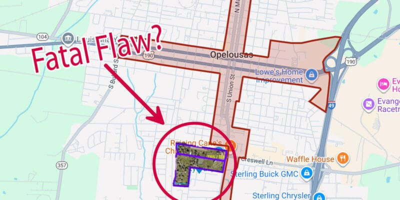
In describing a portion of the southeast area of the district, the Act states that the boundary proceeds from Joyce Drive south to the intersection with Abdalla Boulevard and then south to Hemlock Drive. The only problem is that Abdalla Boulevard and Hemlock Drive DO NOT intersect.
If you follow the boundary line in this area, as shown on the ODDD maps, it selects an arbitrary point to connect to Hemlock Drive. This is not a boundary description outlined with such clarity as to remove any reasonable question in the minds of third persons as to what property is within the district. No person can read this description and establish with reasonable certainty where the boundary line should lie.
Additionally, several parcel numbers used as controlling boundary references in the statute are invalid. Some appear to have never existed as valid identifiers. Others do not correspond to the location the maps claim to encompass. This is not a clerical detail. It is a significant failure in establishing legally defensible boundaries.
The Boundary Fails
When a statute directs officials to proceed along the boundary of a parcel that does not exist or cannot be located from the preceding call, the boundary fails. The Legislature has not fixed the line.
If we follow the example from above further, after you make a leap of faith from Abdalla Boulevard to Hemlock Drive, the description tells you to ‘proceed south to the intersection of Heather Drive’ and then ‘proceed west to the intersection of Heather Drive and the eastern boundary line of the Parcel No. 10579100.’ Parcel number 10579100 doesn’t appear to be valid and thus fails to establish a point from which to proceed next.
Lastly, at least one map of the ODDD shows the district to encompass South City Park. South City Park is parcel number 9114012734 and consists of two separate tracts of land purchased by the City of Opelousas in 1959 (Cash Sale Nos. 178516 and 178575). For South City Park to be included within the district’s boundaries, it requires quite a bit of gymnastics, but let’s see if we can recreate it.
“Approximately” Is Not a Boundary
The statute compounds the problem by repeatedly using the term “approximately” to describe distances along these parcel boundaries. Approximation has a limited role in land descriptions, and only when a fixed monument or surveyed line ultimately controls. Here, the parcel numbers were intended to serve as the controlling reference.
Once the controlling parcel references fail, “approximately” is no longer descriptive—it is discretionary.
For reference, at some point in the district boundary description, we approach the clearly identifiable intersection of Union Street and Heather Street. If we use this as a starting point and then proceed “approximately 3,300 feet” north, we get close to the southeast corner of the 38.92 acres E.P. Smiley tract purchased in 1959 (it is closer to 3,700 feet). However, the legislative description says we should then ‘proceed west along the southern boundary of Parcel No. 9110421578.’ This is impossible!
While parcel number 9110421578 does exist, it is located several miles north of South City Park. That piece of property, which the City of Opelousas purchased in a cash sale dated April 20, 1953, is described as:
A certain tract of land, situated in the Parish of St. Landry, State or Louisiana, just North of the City of Opelousas, containing Twenty-five (25) acres, having a front of Six Hundred and Sixty (660) Feet on Bernard Street, originally referred to as the Public Road leading from Opelousas to Ville Platte, by sufficient depth to make said acreage, located in Sections 50 & 53, in T-6-S, R-4-East, bounded North and West by remaining property of the Heirs of Robert A. Sandoz, South by Bernard Street, heretofore referred to as Public Road leading from Opelousas to Ville Platte, and East by North Side Sub-division to the City of Opelousas…
That precise property description tells us the boundaries with reasonable certainty, unlike those of the ODDD, which are boundless and a recipe for arbitrary power.
Freezing the Error Into Law
Perhaps recognizing the fragility of this approach, the Legislature added an unusual clause at the end of the Act:
The boundaries of the district shall forever be referenced by original parcel numbers as of the effective date of this Act.
This clause does not cure errors but preserves them. And in doing so, it converts a drafting mistake into a permanent constitutional problem. If a parcel number was wrong on the effective date, the statute permanently locks that mistake into law. The defect becomes structural enough to call into question whether their eight years of taxes can survive legal scrutiny.
John Locke, in his Second Treatise on Government in 1689, stated, “Wherever law ends, tyranny begins.” Locke’s warning was not about kings alone. It was about any government that governs without fixed limits. When boundaries dissolve into approximations and administrative guesswork, authority no longer flows from law, but from those who claim to interpret it. That is the precise moment law ends, and arbitrary power and discretion begin.
The Master Plan Reveals the Problem in Practice
In 2021, the ODDD adopted a comprehensive Master Plan. The Plan repeatedly assumes the district’s boundary is settled, yet it never demonstrates that its maps were derived from the statutory description. How could they?
More tellingly, the maps do not even agree with each other! Of the eight maps in the document, only one includes the property of South City Park. All others exclude South City Park from the district boundaries altogether. If the statutory boundary were clear, every map would converge. They do not.
That inconsistency demonstrates that the planners may have been forced to choose an arbitrary boundary when they could not trace one from the law itself. Planning documents cannot define jurisdiction. But they can reveal when jurisdiction is being assumed rather than established.
Jefferson’s Lesson: Measure Before You Govern
Boundary disputes are not a new problem. It is among our country’s oldest, and Thomas Jefferson understood it well. When the United States acquired Louisiana in 1803, Jefferson knew the territory’s borders were ambiguous and much of the land unmapped. He feared that governing unmeasured space would invite arbitrary authority.
So, before settlement and taxation, Jefferson insisted on surveying and mapping. He championed the Public Land Survey System not as a technical convenience, but as a republican safeguard. Jefferson believed that liberty required measurable space — that known lines must bound government power before it could be exercised.
Surveyors initially identified specific landmarks, such as bodies of water and rivers. They surveyed meridians, which run north and south, and baselines, which run east and west, taking great care to ensure these lines were as close to perfect as possible. They knew these lines would form the basis of establishing every township (area of six square miles) and section (area of one square mile) from then on. To this day, we still rely on the Louisiana baseline and the Louisiana meridian, which control areas west of the Mississippi River.
The Contrast With Modern Special Districts
Louisiana’s state boundaries were fixed by treaty and defined by Congress. Municipal boundaries are recorded and judicially settled. They are not elastic. They do not move for convenience.
Special districts, by contrast, are often created with improvised descriptions, administrative parcel identifiers, and “approximate” distances — yet are granted taxing authority by our legislature without the same discipline. When something goes wrong, the district blames the statute, the statute’s author blames the drafter, and the taxpayer is left holding the bill.
This diffusion of responsibility is not accidental. It is inherent in the special-district model.
The Question We’ve Avoided
At this point, the issue is no longer just Opelousas. It is this: Why are we delegating taxing authority to entities whose boundaries are harder to define, harder to enforce, and less accountable than the municipalities they overlap?
Cities already exist to do this work. They have defined boundaries, elected leadership, taxing authority, planning authority, and clear lines of accountability. Special districts duplicate those functions — but without the same clarity or permanence. Further, the individuals serving on the taxing districts’ boards are not elected by the people. Yet, these boards are granted the power to levy taxes! Where is the representation?
The problem with the Opelousas Downtown Development District is not simply that it may have spent money outside its boundaries. The deeper problem is that its boundary was never fixed with the certainty required for taxation in the first place.
Meeting Constitutional Muster
Under the Louisiana Constitution, a special taxing district possesses no inherent authority to levy taxes. Legislative power, including the power of taxation, is vested exclusively in the Legislature (La. Const. art. III, §1), and the Constitution provides that the power of taxation may be exercised only in the manner it prescribes (La. Const. art. VII, §1). A special district exists only as a “political subdivision” to the extent it is authorized by law to perform governmental functions (La. Const. art. VI, §44(2)). Accordingly, any taxing authority exercised by a special district exists solely by legislative authorization and must be strictly confined to the terms of that authorization.
When the Legislature creates a special taxing district but fails to define its territorial boundaries with certainty, it does not merely delegate the administration of a tax—it leaves unresolved a core legislative determination—where the taxing power applies. Because defining the territorial reach of a tax is inseparable from defining the tax itself, leaving that question to administrators, planners, or later interpretation constitutes an improper delegation of legislative responsibility, because the Legislature may not leave the scope of taxation to be decided after the fact.
A Simpler, Stronger Alternative
If downtown Opelousas needs investment, revitalization, and infrastructure, the City of Opelousas already exists to provide it — within boundaries that are known, lawful, and by people who are elected and accountable to the residents.
Creating parallel taxing authorities with fuzzier lines does not solve governance problems. It makes more of them.
If Jefferson insisted on surveying before governing, why are we tolerating governments that govern first and sort out boundaries later? Because when boundaries blur, accountability does too.
And that is not a bug of the special-district system. It is the feature.
Advertisement
Advertisement