Here the latest on what’s supposed to be Hurricane Gordon – it’s still a tropical storm as of now, but it’s supposed to strengthen into a hurricane before slamming into the Mississippi Gulf Coast late tonight – from the National Hurricane Center…
Advertisement
210
WTNT32 KNHC 041150
TCPAT2BULLETIN
Tropical Storm Gordon Intermediate Advisory Number 8A
NWS National Hurricane Center Miami FL AL072018
700 AM CDT Tue Sep 04 2018…GORDON MOVING STEADILY TOWARD THE NORTHERN GULF COAST…
…EXPECTED TO MAKE LANDFALL TONIGHT…SUMMARY OF 700 AM CDT…1200 UTC…INFORMATION
———————————————-
LOCATION…28.1N 86.2W
ABOUT 190 MI…305 KM ESE OF THE MOUTH OF THE MISSISSIPPI RIVER
MAXIMUM SUSTAINED WINDS…65 MPH…100 KM/H
PRESENT MOVEMENT…WNW OR 300 DEGREES AT 15 MPH…25 KM/H
MINIMUM CENTRAL PRESSURE…1004 MB…29.65 INCHESWATCHES AND WARNINGS
——————–
CHANGES WITH THIS ADVISORY:None.
SUMMARY OF WATCHES AND WARNINGS IN EFFECT:
A Storm Surge Warning is in effect for…
* Shell Beach to Dauphin IslandA Storm Surge Watch is in effect for…
* West of Shell Beach to the Mouth of the Mississippi River
* East of Dauphin Island to NavarreA Hurricane Warning is in effect for…
* Mouth of the Pearl River to the Alabama-Florida BorderA Tropical Storm Warning is in effect for…
* West of the Mouth of the Pearl River to east of Morgan City,
Louisiana, including Lake Pontchartrain and Lake Maurepas
* Alabama-Florida Border to Okaloosa-Walton County LineA Storm Surge Warning means there is a danger of life-threatening inundation, from rising water moving inland from the coastline, in the indicated locations. For a depiction of areas at risk, please see the National Weather Service Storm Surge Watch/Warning Graphic, available at hurricanes.gov. This is a life-threatening situation.
Persons located within these areas should take all necessary actions to protect life and property from rising water and the potential for other dangerous conditions. Promptly follow evacuation and other instructions from local officials.
A Storm Surge Watch means there is a possibility of life- threatening inundation, from rising water moving inland from the coastline, in the indicated locations.
A Hurricane Warning means that hurricane conditions are expected somewhere within the warning area. Preparations to protect life and property should be rushed to completion.
A Tropical Storm Warning means that tropical storm conditions are expected somewhere within the warning areas.
For storm information specific to your area, including possible inland watches and warnings, please monitor products issued by your local National Weather Service forecast office.
DISCUSSION AND OUTLOOK
———————-
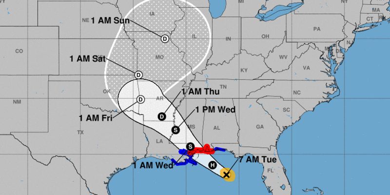
At 700 AM CDT (1200 UTC), the center of Tropical Storm Gordon was located near latitude 28.1 North, longitude 86.2 West. Gordon is moving toward the west-northwest near 15 mph (25 km/h). A west-northwestward to northwestward motion with some decrease in forward speed is expected over the next few days. On the forecast track, the center of Gordon will move across the eastern Gulf of Mexico today, and will approach the north-central Gulf Coast within the warning area late this afternoon or evening, and move inland over the lower Mississippi Valley tonight or early Wednesday.Maximum sustained winds are near 65 mph (100 km/h) with higher gusts. Some strengthening is expected today, and Gordon is forecast to be a hurricane when it makes landfall along the north-central Gulf Coast. Rapid weakening is expected after Gordon moves inland.
Tropical-storm-force winds extend outward up to 80 miles (130 km) from the center. NOAA Buoy 42039, located north of Gordon’s center, recently reported a sustained wind of 43 mph (69 km/h) and a gust to 49 mph (80 km/h).
The minimum central pressure recently reported by NOAA and Air Force Reserve reconnaissance aircraft was 1004 mb (29.65 inches).
HAZARDS AFFECTING LAND
———————-STORM SURGE: The combination of a dangerous storm surge and the tide will cause normally dry areas near the coast to be flooded by rising waters moving inland from the shoreline. The water could reach the following heights above ground somewhere in the indicated areas if the peak surge occurs at the time of high tide…
Shell Beach to Dauphin Island, Alabama…3 to 5 ft. Navarre Florida to Dauphin Island, including Mobile Bay…2 to 4 ft. Shell Beach to the Mouth of Mississippi River…2 to 4 ft. Mouth of the Mississippi River to the Louisiana-Texas border…1 to 2 ft.
The deepest water will occur along the immediate coast near and to the east of the landfall location, where the surge will be accompanied by large waves. Surge-related flooding depends on the relative timing of the surge and the tidal cycle, and can vary greatly over short distances. For information specific to your area, please see products issued by your local National Weather Service forecast office.
RAINFALL: Gordon is expected to produce total rain accumulations of 4 to 8 inches over the western Florida Panhandle, southwest Alabama, southern and central Mississippi, southeastern and northeastern Louisiana, and southern Arkansas, with isolated maximum amounts of 12 inches through late Thursday. This rainfall will cause flash flooding across portions of these areas.
WIND: Tropical storm conditions are expected to begin this afternoon within portions of the warning area, with hurricane conditions expected by this evening in the hurricane warning area.
TORNADOES: A few tornadoes are possible this afternoon through tonight near the coasts of Mississippi, Alabama, and the Florida Panhandle.
NEXT ADVISORY
————-
Next complete advisory at 1000 AM CDT.$$
Forecaster Stewart
Advertisement
Advertisement