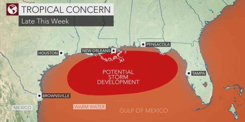
A blast of low pressure out of Georgia is sweeping southward into the Gulf of Mexico, and the result could be the first major storm of the season for Louisiana.
As of Monday afternoon, the National Weather Service gave the tropical system a 30 percent chance of developing by Wednesday afternoon and an 80 percent chance within the next five days. Over the next day or so, that system will make its way into the northeastern part of the Gulf. However, that isn’t the end of the story.
Via KATC in Lafayette:
Once it enters the Gulf late Tuesday into Wednesday conditions are favorable (very warm waters and low shear) for this low to become tropical in nature and gradually strengthen.
Most models have the low strengthening to a tropical depression or weak tropical storm (Barry) by Wednesday evening/Thursday morning as it drifts to the west just south of the Alabama-Mississippi coast.
As of 1PM Monday afternoon the National Hurricane Center has increased the chance of tropical development in the Gulf over the next 48 hours to 30% while there continues to be an 80% chance a disturbance forms in the next 5 days.
What we are watching is a broad trough of low pressure over central Georgia right now.
This low is expected to slowly drift south over the next 24-36 hours and make its way into the northeastern Gulf near the Big Bend region of Florida by Tuesday evening.
Once it enters the Gulf late Tuesday into Wednesday conditions are favorable (very warm waters and low shear) for this low to become tropical in nature and gradually strengthen.
Most models have the low strengthening to a tropical depression or weak tropical storm (Barry) by Wednesday evening/Thursday morning as it drifts to the west just south of the Alabama-Mississippi coast.
Beyond Thursday morning that is when we lose the mid-range model data and have to look at the long range models and upper level flow to figure out where the system will eventually head next.
It’s when the forecast goes beyond the 48-hour range that it becomes more educated guesswork, but the early indicators are that Louisiana coast will be affected.
So, looking at the upper level wind flow at 500 mb or 18,000 feet we see that the low will be situated between 2 large upper level ridges of high pressure, one in the four-corner region and the other over the Bahamas.
The models seem to agree that the ridge over the four corners region will be the dominant feature and steer the tropical system to the west in the Gulf moving it just south of the Louisiana coast on Friday.
Hurricane season officially started June 1, and while the forecast for the year leaned more toward a light/medium season, all it takes is one storm to make it a bad one. It’s that time of year where you should not take chances if you live along the coast. Follow the local forecasts closely, and we’ll keep you updated here if anything develops further.
Advertisement
Advertisement

